Flooding in Burke

- Details
- Created on Friday, 13 November 2015 19:12
- Written by Victor Mwangi
 EAST BURKE – Flood season is approaching and the town of Burke has yet to change its current flooding regulations, to meet the Federal Emergency Management Agency ‘s (FEMA) standards.
Its regulations, which are based from 1980, no longer comply with federal requirements (FEMA) and has taken the town almost three years in revising the standards with the help of the Agency of Natural Resources.
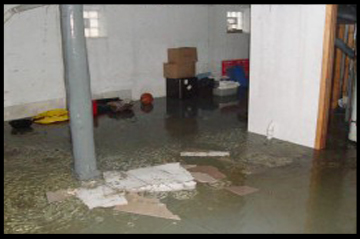
Over the years, there has been flooding, with East Burke Village being among the worst. In March 2008 an ice jam above the narrow bridge in the heart of the village caused the Dish Mill Brook to breach its banks, spilling five feet of water into basements of homes and businesses causing a significant amount of damage.
River garden café, one of the businesses affected, is now permanently closed. While East Burke Sports has built in a river Dike, a wall that blocks the water from coming in, in front of their store to prevent water from rushing into the store incase of a flood.
According to Mike Mann the manager of the store, “further precautions have been taken to protect customers’ equipment by storing them at a higher ground level rather than the basement in the store. “
"The process for the revision of the regulation is to prove only three things.The current regulation does not meet the standard so we just have to bring into compliance with that is required now “, said Al Duey chairman of the planning commission. “The second thing is to look at what could be done to make burke more flood resilient and the third thing is taking advantage of some incentives from the state regarding reimbursement cost incase there was a major disaster by adopting change by-laws.”
The planning commission, which consists of five members, is in charge of drafting by-law changes, making recommendations and submitting them to the public for additional comments before handing it to the selectboard for an approval.
Duey said, areas that are at a higher risk of flooding are residential and businesses that are located near the river. To see an interactive map of the FEMA flood maps and River Corridors, click here.
Currently, there is a final draft that’s just waiting to be reviewed.